
Illinois leads the nation in tornado reports again this year. An active March with multiple damaging storm events inched the state ahead of others, continuing a trend from 2025 when Illinois topped the national count as well. The last two weeks have brought a relative lull, but the pattern has turned active again this week with thunderstorm chances rotating through the state on a near daily basis.
Drought Recovery Across the Cornbelt
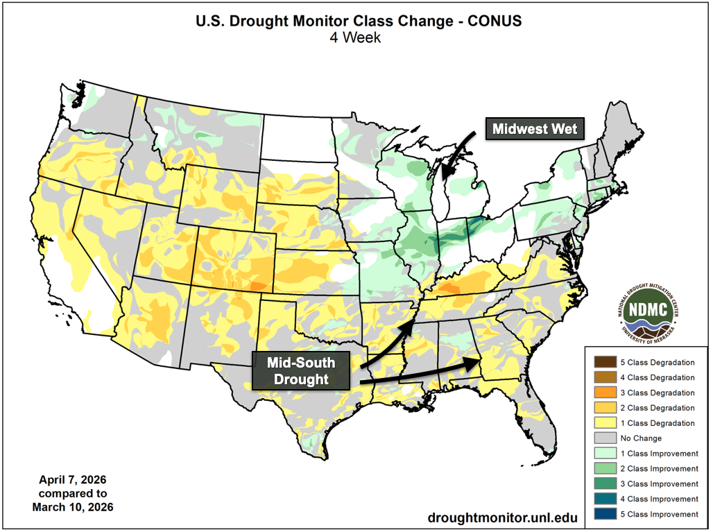
Recent rainfall has dramatically improved the drought situation across the Midwest. Here in Illinois, up to three drought classifications have been removed as this wetter spring has settled in. With virtually the entire state and the wider Central Cornbelt set to receive at least another inch of rain this week, the last remaining drought contours will likely be erased before the final acres go in the ground. Soil moisture values have improved markedly. It will take time for that water to percolate into deeper soil horizons, but the overwintered drought of 25/26 is quickly becoming a distant memory as we look ahead to the warm season.
Provided by Matt Reardon, Nutrien Ag Solutions
While conditions have improved locally, drought has expanded elsewhere. The High Plains saw classifications deepen and spread across Nebraska, Kansas, Colorado, and West Texas. Nebraska has seen a record number of acres burned this year in the central and western portions of the state, where poor winter snowfall compounded by repeated high wind events has produced a dangerous combination of fire weather ingredients.
The Mid-South and portions of the Southeast have also trended drier in recent weeks, a notable shift from last year when the Ohio and Tennessee Rivers were flooding after intense rainfall and severe weather in spring. We often look south early in the year to gauge later season drought risk because it’s not uncommon for drought to expand northward in summer. As Gulf moisture streams north, it can be depleted while traversing drier regions to our south, reducing what eventually reaches us. In years like 2025, when that geography was much wetter from spring rains, the process works in reverse. A wetter Mid-South helps recycle moisture back into the atmosphere where it gets carried north into the Midwest, yielding extra thunderstorm chances and lower drought risk in summer. I’ve jokingly called this the Elvis Rule (or the Graceland Rule) given Memphis’s central location in the Mid-South region. This year, that area is trending notably drier early, and that’s at least one reason not to totally forget the D-word as we get closer to summer.
Near-Term Forecast
We certainly don’t see any dry concerns for the near term. This week’s forecast is very active and next week looks similarly wet and warm. Long-range models continue to show persistent troughing across the Western U.S., which will usher low pressure systems on their usual spring migration from the Continental Divide across the Midwest. These will bring rain chances and potential severe weather, as April in Illinois tends to do.
A cold front will pass through this weekend, dropping temperatures back into the 30s by Sunday morning and returning frost and freeze risk to the area. The overnight lows are still uncertain early this week, and there’s enough in the data to be wary of calling it a wrap on frost season until we get through that cooldown. As of this writing, overnight minimums on Sunday (4/19) and Monday (4/20) are running 38°F and 36°F respectively across Central Illinois. Counties north of the Illinois River are much closer to freezing at 33°F and 32°F. Next week is trending warmer, and we may end up talking about the season’s last freeze this weekend, if it even materializes.
El Niño and the Summer Outlook
In the longer range, there is at least one indicator suggesting we might trend drier locally through late spring and early summer.
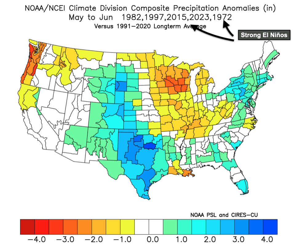
Sea surface temperatures in the Central Pacific continue their rapid warming pace this spring. By all indications, we are approaching what’s likely to be a strong El Niño in 2026. Last week the Climate Prediction Center issued its first El Niño Watch of the year, expecting El Niño to emerge this summer. Coupled forecasts that account for both ocean temperatures and the atmosphere suggest this year’s episode could be very strong. That aligns with what we’re seeing now in the Pacific, atmospheric conditions highly indicative of past El Niño events. When we look at late spring weather conditions during past rapidly strengthening El Niño events, we find a consistent dry bias across the Midwest in May and June. Illinoisans might remember the dry start to 2023 during our last El Niño episode. Extended forecasts from the NMME and ECMWF point in the same direction, favoring drier conditions across the Midwest in May and June.
Provided by Matt Reardon, Nutrien Ag Solutions
Couple that with the drought building to our south and there are at least two sources of potential summer dryness worth watching. Many of those strong El Niño years did eventually turn wetter by midsummer, though. Several were particularly stormy, producing overnight convective complexes and ultimately a healthy crop despite early season dryness. Long-range seasonal models right now are largely favorable for midsummer moisture, consistent with that pattern. A region I watch closely this time of year is the Gulf of Alaska, if not a wider stretch of the Northeast Pacific bracketing the west coasts of the United States and Canada. When this region turns cooler in April and May, it often portends summer drought risk in the Central United States. It’s good news then that those water temperatures remain fairly warm across that region with some localized cooling closer to Alaska. All that to say, while there’s some risk for drier conditions early this summer, the hallmark indicators of a midsummer drought aren’t showing up yet. We’ll keep watching.
Matt Reardon
matt.reardon@nutrien.com
FIND US ON