
The first football tailgate of the year is always circled in red on my calendar—it’s one of my favorite days. This season, my team, the Fighting Illini, has six more home games, with one already in the books from last Thursday. That means six more Saturdays to enjoy the crisp fall weather, the aroma of freshly fallen leaves, and the delicious scents of burgers, brats, and hot dogs on the grill, all while the temperatures get cooler as we move toward November. For me, these tailgates are a highlight of the year. They aren’t just about football; they’re about creating lasting memories with friends and family. As an Illinois Football fan, you sometimes need to find joy in these other aspects of the gameday experience, especially if the team isn’t performing at its best—only sometimes, though! There’s nothing quite like spending a chilly fall day with loved ones, either eagerly anticipating the big game or celebrating a big win afterward. I may be biased, but I believe the weather plays a big role in making these gamedays special. That’s why you’ll often find me checking the forecast as the next home game approaches.
The fall forecast is also crucial for crops. In Illinois, the median date for the first frost ranges from the first week of October in the northernmost counties to the third week in the southernmost areas. About once every ten years, we might see a frost as early as mid to late September across much of the state. Since our ability to accurately forecast cold air outbreaks only extends to about 10-14 days, we’re now officially on frost — and tailgate — watch for 2024.

Figure 1: ISWS Median Date of First 32°F Freeze (1981-2010)
Cooler temperatures and crisp, fall-like mornings are expected to continue through the first half of the month. After enduring excessive heat warnings just two weeks ago, we’re now back to the cooler temperatures that make us think of fall—and football. This weekend, we can expect the coldest temperatures so far, with overnight lows dropping to around 40°F in some counties. However, it’s still too early in the month for frost, and the air mass isn’t quite cold enough yet. That’s not the case for the northern Corn Belt, where frost is more likely. As the cooler air moves in, we’ll also see drier conditions, thanks to high pressure settling over the Great Lakes for the next week or two. Even with these cooler temperatures, the weather looks favorable for this year’s dry down because of lower humidity and a lack of rain. While no counties in the state are observing drought conditions, there are some lingering soil moisture deficits in eastern and southern counties which will likely worsen through the month.
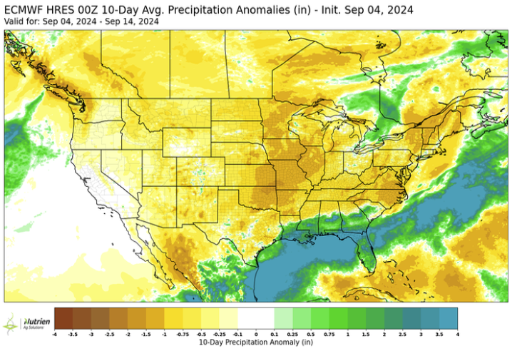
Figure 2: ECMWF 10-Day Precipitation Anomaly
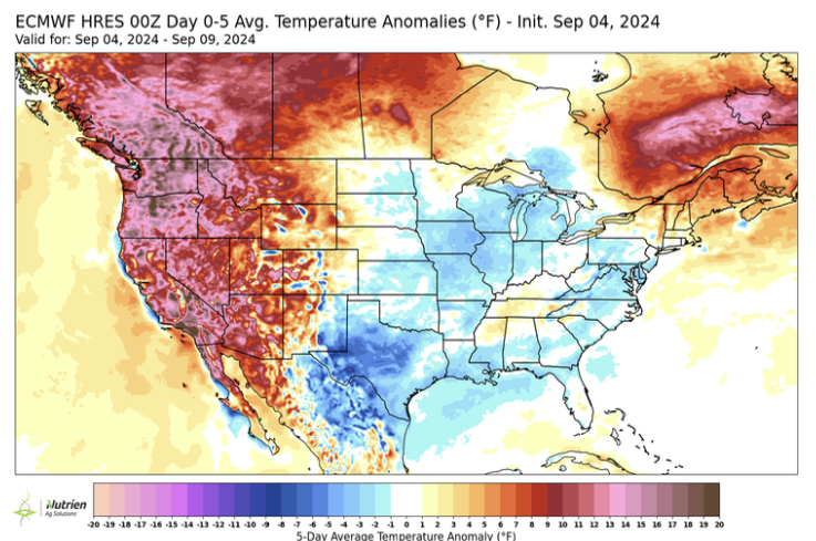
Figure 3: ECMWF 5 Day Temperature Anomaly
Looking ahead, long-range forecast models predict a shift toward warmer conditions later in the month. This forecast aligns with a few different predictive tools. First, the Pacific Ocean’s sea surface temperature pattern indicates a developing La Niña, which is expected to start this fall. Past weak La Niña events have often led to warmer-than-average temperatures in the Midwest during the fall. Second, forecast models of convective patterns in the West Pacific suggest a higher chance of upper-level ridging over the Midwest or Central Canada, which can result in above-average temperatures for much of the Corn Belt. This portends a shift to warmer temperatures in later September that could persist into October. This would lower the chance for an early frost despite the near-term cooldown. This pattern could also direct any future hurricanes into the Gulf of Mexico as we move through the peak of hurricane season.
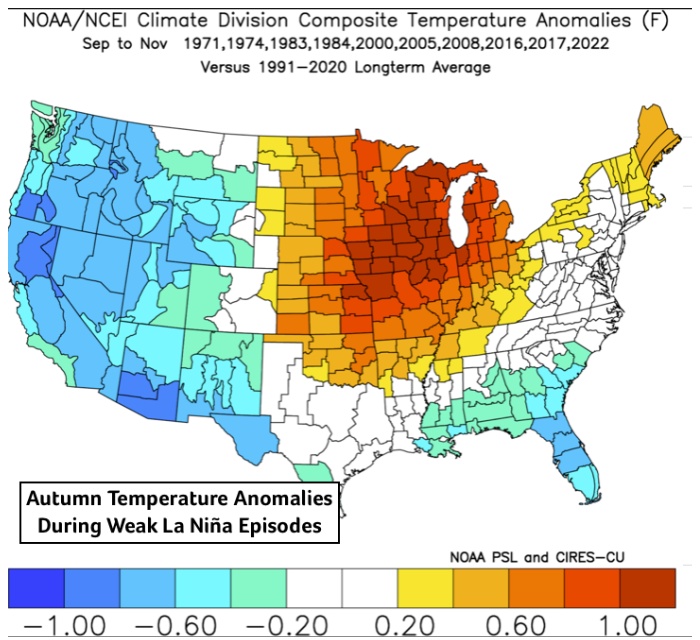
Figure 4: Composite Temp Anomalies for Fall (Weak La Niña)
Despite predictions of above-average hurricane activity earlier this year, this season has been surprisingly quiet just as we reach what is usually the peak period for storms. In early July, Hurricane Beryl made history as the earliest Category 5 storm recorded in the Atlantic, though it weakened to a Category 1 before hitting Texas. Later, Hurricane Debby caused widespread flooding in the Southeast. Both storms caused over a billion dollars in damage. Yet, after a fast start, the season has slowed considerably. The lack of instability in the Tropical Atlantic’s atmosphere and an unusual African Monsoon are likely behind the recent lull in tropical cyclone development, despite very warm Atlantic waters and low wind shear—conditions typically favorable for hurricanes. As I always say, regardless of what the seasonal forecast predicts, it only takes one major storm to make a significant impact. This is especially true for those living and working in hurricane-prone areas in the Southeast or Caribbean. We’re not out of danger yet.
The hurricane season officially ends on November 30th, and soon after that, we’ll be welcoming winter in Illinois. We’re likely to see La Niña conditions officially develop in the Pacific, which usually means colder and wetter weather for the Corn Belt during winter. While seasonal forecasts are tricky and often inaccurate—as we’ve seen with this year’s hurricane season—there are better signals for snow and cold snaps this winter.
The Fighting Illini will play their final home game on November 16th against Michigan State, which is about ten weeks away. By then, the average high temperature in Champaign, IL, will have dropped from around 82°F in early September to about 50°F, with average lows nearing freezing. By that time, we’ll also be near the end of the hurricane season, and what looks like a great crop will mostly be harvested. I have ten weeks to make more autumn memories, enjoying fall one Saturday at a time.
 and then