The 2019 weather year was chaotic and variable, with multiple extreme events that added tremendous difficulty for farmers and producers. Here I’ll review the eventful 2019 weather year and offer an outlook for winter/spring 2020.
Wet Winter & Spring

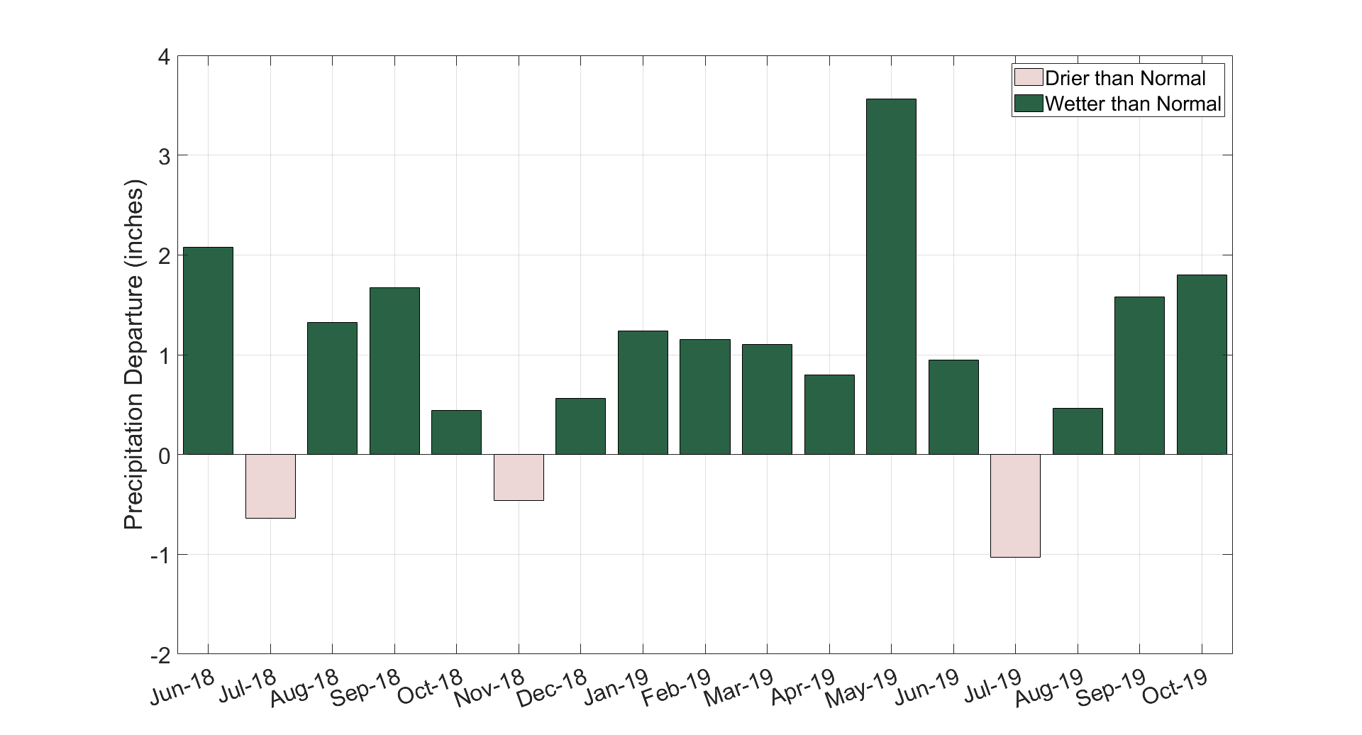
Statewide monthly precipitation departure from the 30-year normal from June 2018 to October 2019. Data were provided by the Midwestern Regional Climate Center (mrcc.illinois.edu)
2019 started with preexisting wet conditions, as five of the last seven months of 2018 were wetter than normal statewide. This was followed by above normal precipitation in January and February, saturating soils across the region. On top of the saturated soils in the Upper Midwest was an above normal snowpack, which persisted well into March and amplified the record precipitation in spring to create flooding conditions throughout the state. Because of precipitation, soil, and snow conditions, flooding was not confined to channels, and many upland fields were flooded in addition to fields in valleys and low-lying areas.
The persistent upper-level atmospheric pattern maintained a trough or dip in the primary storm track well into late spring, continuing the frequent precipitation across the state over the first six months of 2019. Statewide precipitation totals for May 2019 (8.16”) were the third highest and nearly twice the 30-year normal. This helped position 2019 as the wettest January-to-June on record in Illinois since 1895. Statewide, 2019 was only the fourth year on record in which all six months between January and June were wetter than their long-term average. The previous three years were 1974, 1998, and 2000. However, the total January-to-June statewide precipitation this year (28.5 inches) was nearly two inches higher than any of those previous three years.
Wet Summer in the North, Dry in the Central and South
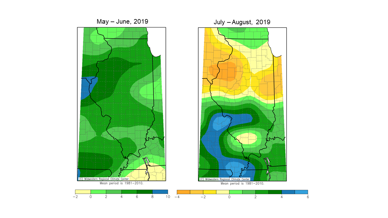
A warmer and drier than normal July provided some reprieve from the cool, wet conditions that persisted for the first half of 2019. Although rains returned in August to most of northern and southern Illinois, dryness persisted for a broad area between Interstate 70 and 80. The area around the Quad Cities that had experienced a precipitation surplus of 6 – 8 inches in May and June flipped to a 3- to 4-inch rainfall deficit in July and August.
Precipitation departure (inches) from 30-year average in (left) May and June and (right) July and August 2019. Data were provided by the Midwestern Regional Climate Center (mrcc.illinois.edu).
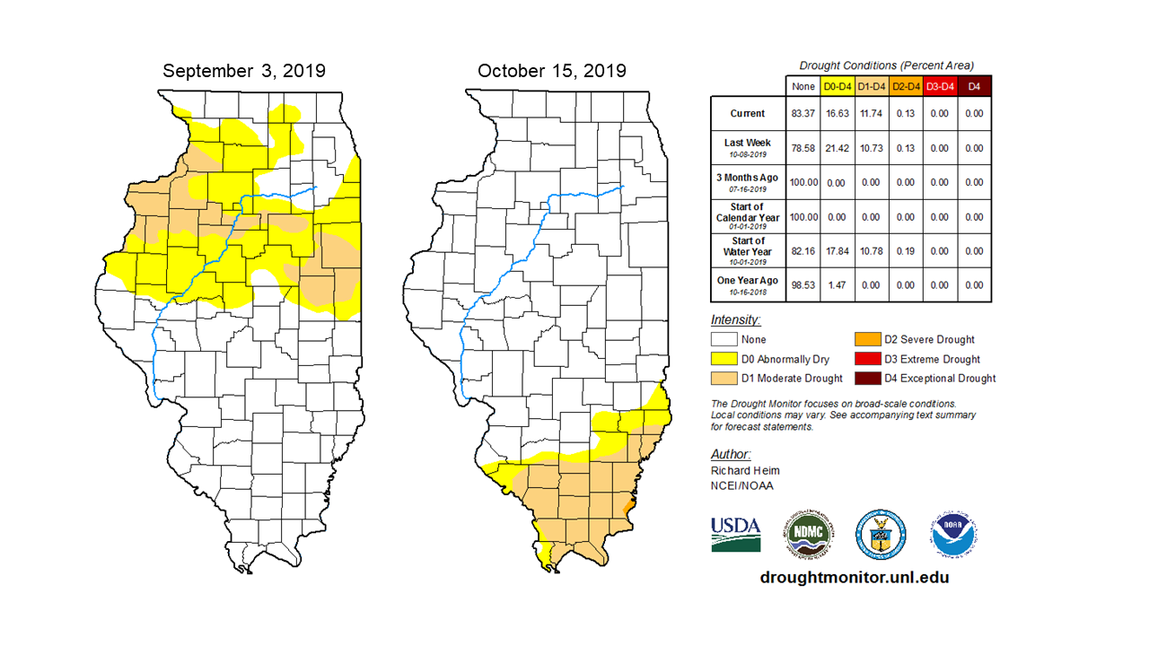
In early September, drought was indicated in Illinois by the U.S. Drought Monitor for the first time since August 2018, with a band of moderate drought stretching from Rock Island to Vermilion Counties. As the northern half of the state received multiple, heavy rainfall events in September, the southern half of the state experienced one of the driest Septembers on record. A large ridge in the upper atmosphere positioned itself over the southeastern U.S. in early September and persisted well into October, causing extremely dry, hot conditions for that region. The combination of dryness and heat caused a rapid onset or flash drought in the southeast, including parts of southern Illinois. September was among the top 10 driest in all Illinois counties south of Interstate 64 except two (Alexander and Randolph). Less than a quarter of an inch of rain fell in September in Hardin and Gallatin Counties. The southern Illinois drought peaked in early October, with most of the region in moderate to severe drought, according to the U.S. Drought Monitor.
U.S. Drought Monitor maps from (left) September 3rd and (right) October 15th. Maps provided by the National Drought Mitigation Center (droughtmonitor.unl.edu).
At the same time southern Illinois was enduring drought, much of northern Illinois had not dried out from the very wet spring. In fact, the same September that brought less than a quarter of an inch of rain to deep southern Illinois produced over 10 inches of rain to most areas of northwestern Illinois. It was the wettest September on record for five counties in Illinois (Bureau, Stark, Carroll, Jo Daviess, and Stephenson). The persistent wetness in northern Illinois significantly postponed drying and harvest of an already delayed crop. Impact reports from southern Illinois were more mixed, with some reporting estimated yield losses due to the drought and heat and others reporting the hot, dry conditions helping the late planted crops along to maturity.
The End – Heat to Cold, Early Snow
In mid-October an upper-level pattern established a trough in the jet stream to our west, bringing rain to drought-stricken southern Illinois and increased the occurrence of cold air outbreaks across the Midwest. Most of the state experienced the first freeze in mid-October, and the first hard freeze in late October. This year’s first fall hard freeze was slightly later than normal in northern Illinois and a week or two earlier than normal in southern Illinois.
Along with a significant drop in temperatures, most of the state experienced the first snowfall on the last two nights of October. October snowfall totals ranged from over 8 inches in Stephenson County to just over a tenth of an inch in Montgomery County. Measurable snowfall before Halloween is unusual for most of central and southern Illinois, but not unprecedented. However, significant snowfall in northern and central Illinois in late October and early November continued to delay harvest as well as causing issues with propane supply and delivery.
Winter to Spring 2020 Outlook
A large portion of monthly to seasonal winter Midwest climate predictability comes from the El Niño-Southern Oscillation, also known as ENSO. This year ENSO is in its neutral phase and is forecasted to remain so for much of the winter and spring.
In the absence of a strong ENSO signal, climate scientists look at other patterns and long-term trends that can provide some winter season predictability. The NOAA Climate Prediction Center winter outlook, as of November 21st, depicts elevated odds of above normal precipitation across the state from December to February. This is primarily based on long-term trends, which show winters in the Midwest getting wetter over the past several decades. The same outlooks for winter temperatures show equal chances of above normal, normal, and below normal temperatures across the state.
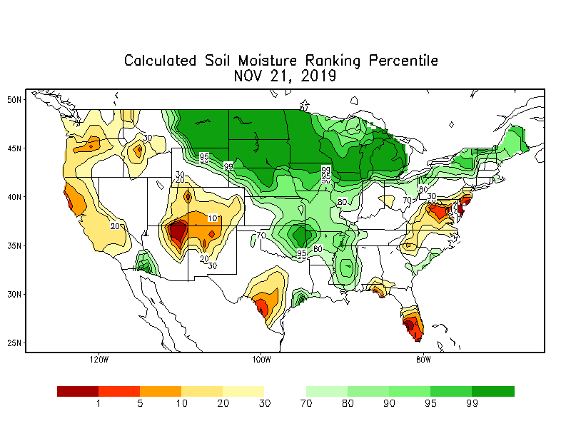
Increased odds of above normal precipitation are also shown in the Climate Prediction Center’s spring (March to May) outlook, as of November 21st. Despite seasonal outlook uncertainty, it is important to note that current hydrologic conditions are primed for excess water issues if the winter and spring do indeed produce above-normal precipitation. Soil moisture, based on Climate Prediction Center models, is saturated or near saturation in most of northern and central Illinois and above average in southern Illinois. As soils begin to freeze, this moisture will be essentially “locked in,” increasing the chance of spring flooding if precipitation is above normal this winter season. Additionally, all U.S. Geologic Survey stream gages north of Interstate 70 are above normal, and many in northern Illinois are above the 90th percentile, indicating well-above-average streamflow.
Soil moisture expressed as a percentile across the U.S. as of November 21st. Values exceeding 90% indicate soils are near saturation.
Summary
The 2019 weather year was one to remember, or maybe forget. Frequent, heavy winter and spring precipitation on top of already saturated soils and swollen streams created serious flooding issues in both upland and lowland fields. The persistence of spring rainfall and the reduced number of consecutive dry days in April and May significantly delayed field preparation and planting throughout the state.
Although northern Illinois was subjected to above-average precipitation throughout most of the summer and into the fall, central and southern Illinois experienced drought that varied from moderate to severe intensity. Although a much warmer than average September helped push late-planted crops toward maturity in the northern half of the state, exceedingly dry conditions in southern Illinois likely affected yields and the timing of both soybean harvest and winter wheat planting.
Despite an early start to winter weather this season, the absence of a strong ENSO signal leaves sizeable uncertainty in winter and spring season outlooks. Long-term trends show winters and springs in Illinois are getting wetter on average; however, year to year variability largely outweighs this trend for a given season. More important are the antecedent wet conditions across the state, with saturated soils and elevated stream levels. Given Climate Prediction Center winter/spring outlooks and our current conditions, there is a reasonable chance that much of the state will be dealing with excess water issues come February and March.


