
Already this month, the weather has shown us the full spectrum of what March can deliver. Tornadoes. Blizzards. Near-summer warmth followed by brutal cold and blowing snow. The clash of seasons playing out across the region is a textbook reminder of just how volatile spring can be here in the Midwest, and 2026 is putting that volatility on full display.
What started as a mild stretch of temperatures with ample rains has now given way to overnight lows in the teens and blizzard warnings. Chicago managed to celebrate St. Patrick’s Day over the weekend just ahead of what looks like winter’s last real gasp this week.
Last Week’s Historic Severe Weather
Last week brought historic severe weather to northern Illinois, including a deadly EF-3 tornado that tore through southern Kankakee and the village of Aroma Park on the evening of March 10. The tornado, spawned by a powerful supercell that originated near Pontiac, tracked 36.6 miles from west of Aroma Park across the Illinois-Indiana border to near DeMotte, Indiana. Peak winds reached an estimated 150 mph. Nearly 500 structures were damaged across Kankakee County, with at least 30 homes destroyed. Three people lost their lives: two in Lake Village, Indiana and one in Aroma Park.
The same supercell also produced extraordinarily large hail. Meteorologist Victor Gensini of Northern Illinois University collected a hailstone from the Kankakee area and measured it at his lab: 7.125 inches in diameter, 16 inches in circumference, and 16.5 ounces in weight. If verified by the state climatologist, it would shatter the previous Illinois record of 4.75 inches set in
Minooka back in June 2015. Hail of that magnitude is virtually unheard of in Illinois, where severe storms tend to produce a greater mix of wind and tornadoes compared to the icier supercells common across the Great Plains.
A Quiet, Warmer Stretch Ahead
The good news for those weary of large hail, tornadoes, and violent weather in general is that we are entering a particularly quiet stretch through the end of the month, and one that will likely skew warmer than average. It’s not lost on this meteorologist that we appear to be on track to deliver on the old saying that March “comes in like a lion and goes out like a lamb.”
The next 10 days look particularly dry for the Midwest, with one or two cold fronts likely to bring only meager shower or storm chances. Temperatures should be generally on the rise as well, with this coming weekend looking especially pleasant. Highs in the upper 60s to low 70s are in play for much of Illinois.
The Spring Predictability Barrier
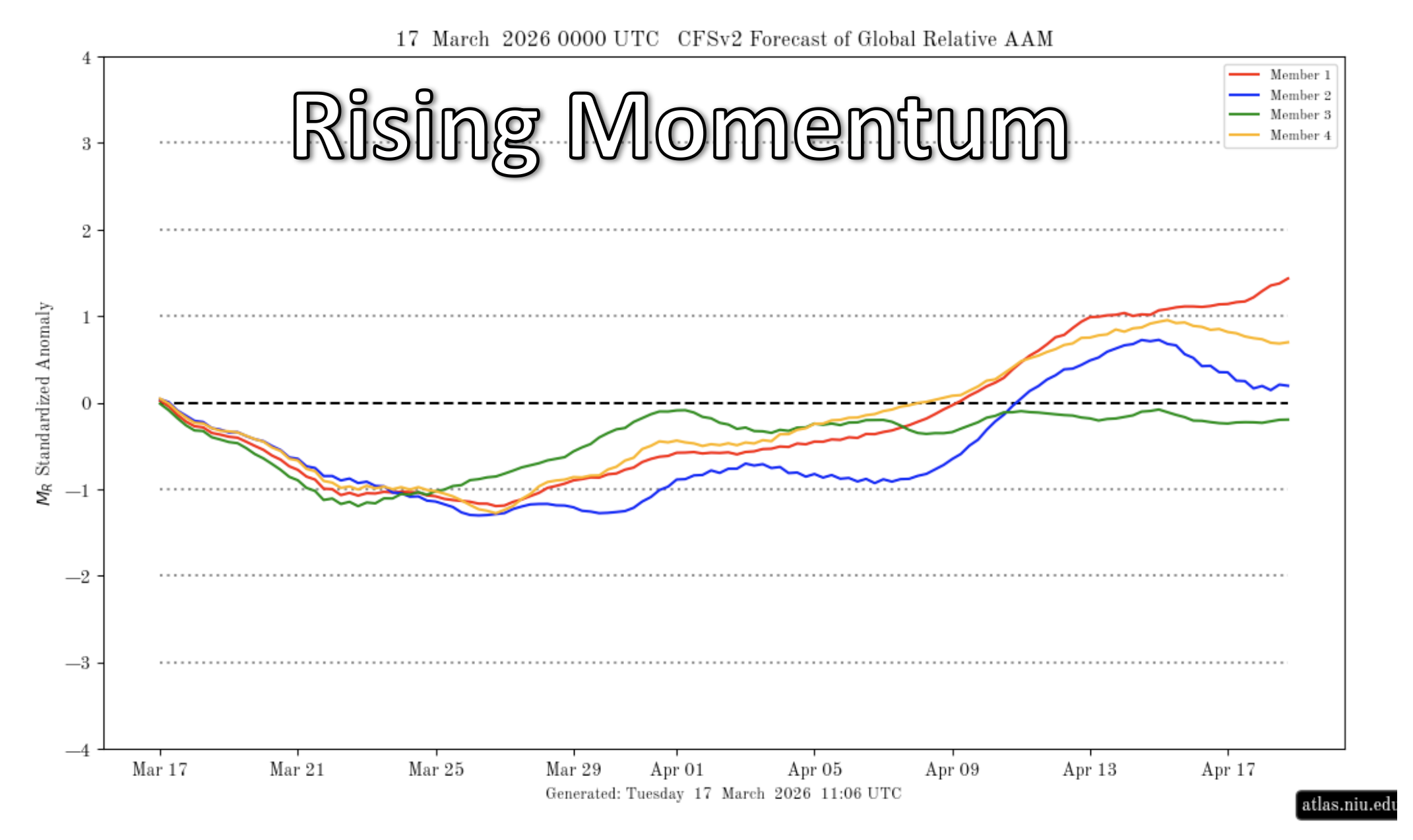
Late March is always an interesting time for forecasters. We are now entering what meteorologists call the spring predictability barrier, sometimes referred to as the spring predictability gap. Rapid shifts in the jet stream pattern cause forecasts to jump around more than usual and limit how far out we can reliably anticipate these pattern changes. It also means that until we see which areas eventually hit or miss on spring rains, we will have a poor understanding of where the worst drought pressures may build heading into summer 2026.
One tool we do have is atmospheric angular momentum, which is essentially a measure of how much energy is available in the jet stream to drive storm development, frontal passages, and low-pressure systems. That momentum is expected to decrease through the end of March, which aligns with this upcoming quieter pattern. That said, long-range models reverse that trend in April, with momentum expected to increase and potentially return the Midwest to a more active weather pattern by mid-month. An active April would almost certainly include renewed severe weather chances, as our severe weather season climatologically peaks between April and June in this part of the country.
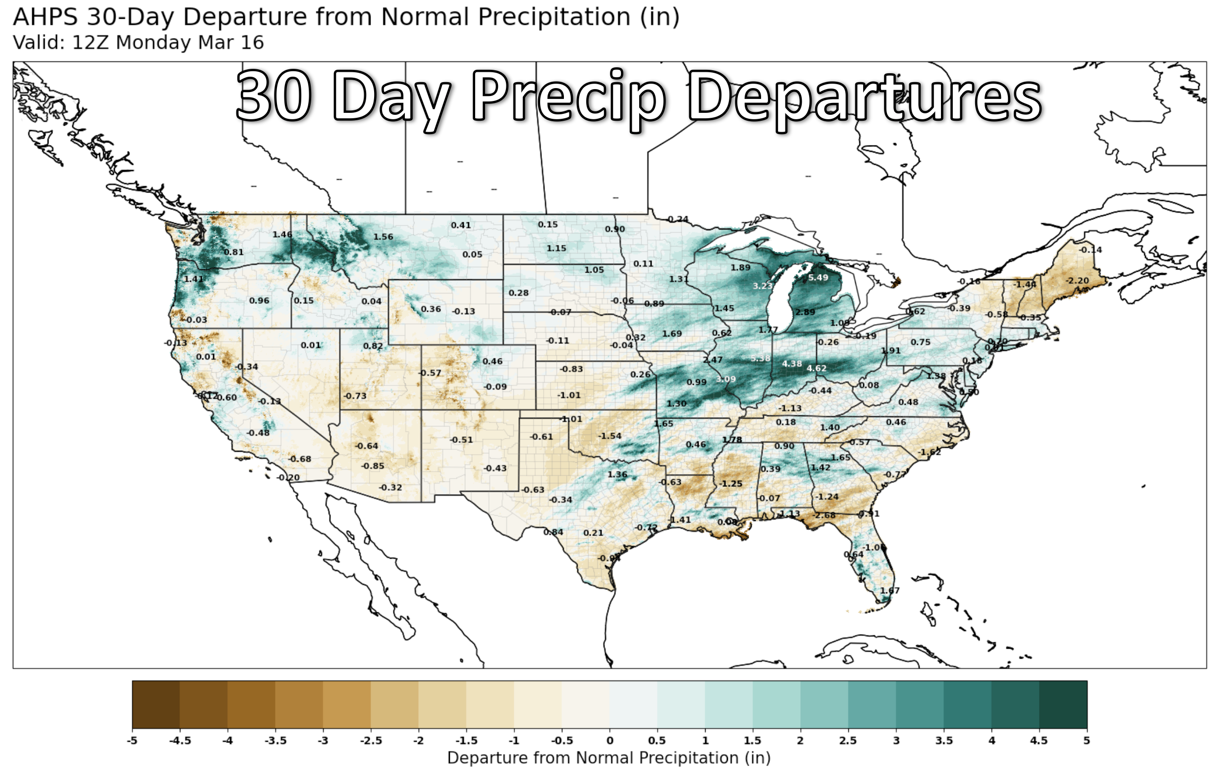
Drought and Soil Moisture: Where Things Stand
At least with respect to drought risk as it stands today, recent rains and even some snow have improved soil moisture values significantly across the region in recent weeks. Many growers I’ve spoken with have expressed satisfaction with current moisture levels, assuming planting proceeds on schedule this April and early May.
That’s a notable sentiment given that many areas across the state are still classified in severe drought according to the latest U.S. Drought Monitor. The Midwest did see improvements in the most recent update, but the lingering drought designation reflects the long-term precipitation deficits that built up over the winter. If trends hold for April, which looks primed to return moisture, albeit potentially coupled with severe storm chances, that would work to further improve soil conditions after this upcoming drier stretch.
It’s worth noting that by about this time next month we’ll be passing median last-freeze dates for most counties in Illinois. Given that April may coincide with an active pattern and potentially some potent cold fronts, I don’t see anything to suggest that last freeze is likely to come earlier than normal this spring. Plan accordingly.
The Pacific and What It Could Mean for Summer
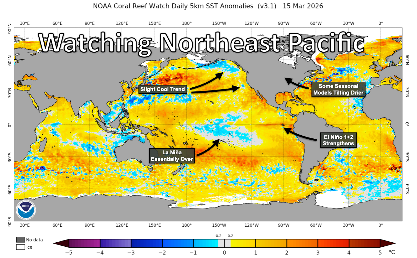
My attention has also turned to the Pacific early in the season for critical changes in sea surface temperature patterns.
Water temperatures in the central equatorial Pacific continue to warm at a rapid pace, outpacing just about any year in the recent modern record. NOAA issued an El Nino Watch in mid-March, and the Climate Prediction Center currently gives a 62% probability that El Nino will emerge by June through August 2026. Some forecasting outlets have flagged the potential for this event to strengthen significantly, possibly reaching strong or even “super” El Nino thresholds later in the year.
While El Nino can hold useful predictive value for North American weather in the fall and winter months, its connection to mid-summer precipitation patterns across the Corn Belt is a loose one. El Nino tends to favor slightly wetter growing seasons on average, but we are not talking about strong correlations.
My focus is closer to home, in the Northeast Pacific specifically. The stretch of water off North America’s western coastline often holds clues as to the level of drought pressure we experience in the central United States during mid-summer. In recent years where that drought risk has materialized, it has been almost always preceded by cooling sea surface temperatures in the Northeast Pacific. In recent weeks, temperatures there have been trending cooler, even as the central Pacific warms in its march toward El Nino.
Coupled with some recent seasonal model guidance that has tilted slightly drier for the Midwest in June, July, and August, I am ever so slightly more concerned about summer drought here in mid-March than I was just a few weeks ago. To say anything more definitively, given how uncertain seasonal trends are to begin with, would be unwise this early in the season. What I do know is that we have plenty to watch come April.
Looking Ahead
Rising atmospheric momentum is likely to return thunder and rainfall to a region that could use a bit more moisture ahead of planting. Changing sea surface temperatures could help shape that thunderstorm activity come summer. And a local basketball team might just be playing into next month if they get lucky enough in the NCAA tournament.
I’d say that makes for a fun few weeks as we settle into the long spring predictability gap.
Matt Reardon
matt.reardon@nutrien.com
 and then