
There are subtle reminders everywhere: blue skies, crunchy lawns, and other familiar signs that echo the early autumn conditions of recent years. It may be perfect weather for tailgates and football, but it does little to help yards, grain fill, or fire weather risk. Once again, we’re staring down a dry autumn across much of the Midwest, and like in past years, it began in August.
That month, much of the state, particularly counties south of I-80, experienced very dry conditions. For climate divisions along and south of I-70, it ranked among the ten driest Augusts in Illinois’ 133-year precipitation record. Crops were clearly stressed as they finished, with soybeans especially sensitive to the lack of rainfall during pod fill. Northern counties, meanwhile, saw flooding earlier in the month, especially in the Chicago metro, before conditions there also turned dry. Scattered storms in early September brought some moisture, but amounts were light and far from widespread. As a result, drying fields and even a few early harvests are already a common sight in rural areas. Today, as I write, the sky outside is a clear deep blue, at least free of the gray wildfire smoke that so often drifted overhead this summer.
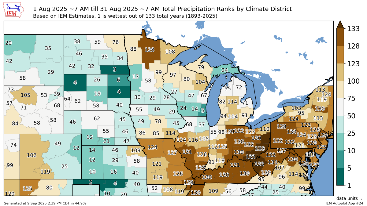
August 2025 Precipitation Ranks by Climate District
A cooler end to summer brought an early taste of fall, with overnight lows dipping into the 40s well into early September. But this week and next, temperatures are forecast to rebound as the familiar “second summer” pattern brings warmth through at least the third week of the month. Highs will return to the 90s across much of the state, with overnight lows back into the 60s. That warmth, paired with already-dry soils and crops drying down more quickly than usual, could produce an elevated fire weather risk during harvest, especially since this stretch is expected to last a couple of weeks. This setup will sound familiar to those who have followed recent Illinois autumns, since dry conditions have prevailed for three straight falls. Right on cue, Mississippi River levels at Memphis have once again dropped below low stage, just as they did the past three years. If dry weather persists through another month, barge traffic disruptions could return along the nation’s most important waterway.
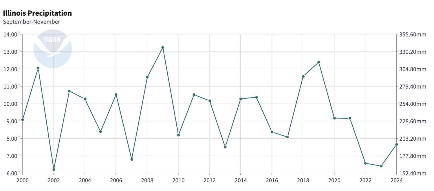
NOAA Illinois Autumn (SON) Precipitation Amounts (2000 – 2024)
The extended fall outlook doesn’t offer much hope for wetter conditions, at least not until early winter. In fact, recent ECMWF extended and seasonal forecasts have shifted even drier through October. While forecasts beyond 10 to 14 days should be viewed with caution, these align with seasonal analogs and weak La Niña-like signals in the Pacific, which have historically influenced drier autumns in Illinois. Minimal tropical activity in the Atlantic since Hurricane Erin, which briefly reached Category 5 before curving out to sea, has further reduced the chance of remnant tropical systems providing that rainfall. Normally, we would expect better rain chances with rising temperatures this week, but the weekend forecast isn’t encouraging. While some models suggest showers and storms, most show only spotty amounts in isolated counties, especially across the northeast near I-57.
Counties that miss this weekend’s limited rain may be facing an extended dry stretch into next week, according to long-range guidance. While there are encouraging signs of precipitation by mid-to-late next week, we will need to see the pattern prove it can deliver meaningful rainfall before putting much confidence in it.
La Niña conditions appear increasingly likely this autumn, with the Climate Prediction Center maintaining its La Niña watch. While impacts are expected to be greater in the western U.S. and tropics, there is some historical tendency for more seasonable winter temperatures and enhanced precipitation in the Ohio River Valley during La Niña years. I cannot say with confidence that this will translate to more snow, or even more precipitation, for Illinois this winter, but it does provide some hope that moisture returns as we transition from a presently dry autumn toward the holidays. Ultimately, the week-to-week variability of the jet stream, low- and high-pressure systems, and major winter storms will drive the narrative. ENSO’s influence, whether La Niña or El Niño, usually only shows up in the seasonal totals, not in individual weeks.
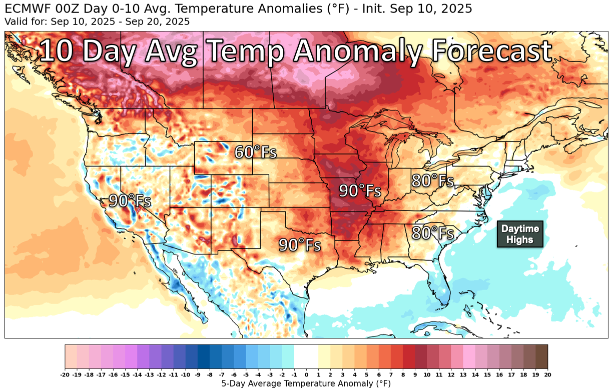
ECMWF 10 Day Average Temperature Anomaly Forecast (9/10 – 9/20)
What is striking about this September update is how little there is to say about Atlantic hurricanes. The basin has gone nearly silent during what is usually the peak of the season. By contrast, the eastern Pacific has been active, including Hurricane Kiko, which recently weakened north of Hawaii. Another storm is possible in the next 10 days. In the Atlantic, unfavorable conditions such as greater atmospheric stability and surges of Saharan dust have choked off developing storms. Conditions may improve slightly as September progresses, but it is hard not to echo our own local rainfall situation: “I’ll believe it when I see it.”
By the time we meet again in October, harvest will be well underway if not complete in some areas. The extent of fire risk during those weeks will depend heavily on whether meaningful rainfall returns. For now, wind has not been a major factor. Few strong low-pressure systems have developed during the dry stretch, which has kept windy days to a minimum. That has been welcome, though not surprising, as those same systems are usually what deliver rain. But as we move deeper into fall, stronger lows will eventually return. If they bring dry cold fronts with gusty winds but little rain, fire concerns could quickly escalate, straining local departments and filling the skies with smoke plumes across Illinois fields.
Let’s stay cautious this season and safe through what promises to be a busy harvest and, soon enough, an active winter.
Matt Reardon
matt.reardon@nutrien.com
 and then