
Late April and early May have brought a relative lull in severe weather across Illinois and the broader Midwest. Much of the severe thunderstorm activity has shifted south, concentrating over the Southern Plains. Texas, for instance, has experienced significant severe weather, including large hail, damaging winds, and isolated tornadoes. This same storm focus has resulted in widespread flooding, with Oklahoma City recording over 13 inches of rainfall in the past 30 days and breaking their April record.
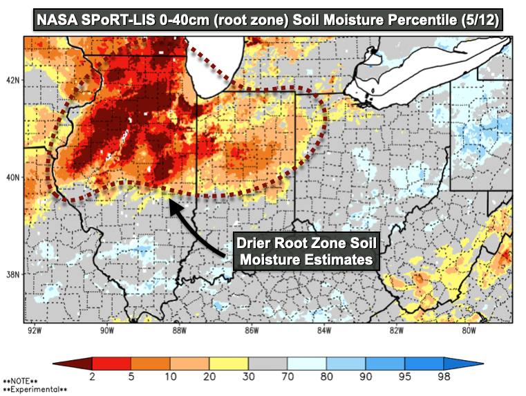
In contrast, Illinois has remained drier, with only a few remnants of these storm systems moving through the region. The southern half of the state and especially counties near the Ohio River, have seen more frequent precipitation events since the intense rainfall event in early April. While occasional rainfalls remain in the forecast, the broader trend has been one of reduced storm activity and drying soils. Although localized drought conditions have eased over the past six weeks, soil moisture estimates north of I-72 remain well below average for this time of year. This extended dry period has created favorable conditions for planting and fieldwork across the Midwest this week. However, if the dry trend continues unabated, it could set the stage for a return to drought conditions later this month.
Much like Illinois basketball recruiting news, my attention has recently turned to Europe, where drought concerns have been steadily rising. Germany, in particular, is experiencing near-record spring dryness (JRC News, 2025), but the issue stretches well beyond Central Europe. Dry conditions persist across Ukraine, the Balkans, and Turkey. Early seasonal forecasts indicate that this drier trend could extend into the heart of the European summer. Given that the European Union is the second-largest importer of soybeans from Brazil and the United States (Reuters, 2025), this could have broader agricultural implications if the dry spell continues.
Here in the U.S., the atmosphere has recently shown signs of reduced jet stream intensity and momentum, a pattern often associated with blocking and drought risk. Persistent cut-off lows over the Four Corners region have triggered frequent storms and heavy rainfall across the Southern Plains — a region that faced increasing drought risk as recently as late winter. However, these slow-moving systems may indicate a broader atmospheric pattern known as blocking, characterized by persistent ridges and troughs. If this sluggish atmospheric state extends into June or July, the potential for a large summer ridge — the type that historically leads to significant heat and water stress — becomes a more pressing concern. The current weather setup may be an early indication of the atmosphere’s tendency to lock into a more stagnant pattern as the summer progresses.
The latest seasonal outlook from the European Centre for Medium-Range Weather Forecasts (ECMWF), one of the most widely referenced long-range models, underscores this drought risk. It projects below-average precipitation across much of the Central United States, including parts of Northern Illinois. However, there are two important caveats to this outlook: timing is critical, and seasonal forecasts often come with considerable uncertainty. A dry summer doesn’t necessarily equate to poor crop yields if the limited rain that does fall is well-timed during critical growth stages in late July or early August. Historical data shows that even modestly dry summers can still produce above-trend yields if precipitation aligns with peak water demand.
An additional factor that could help mitigate some of these drought risks is the current state of ocean temperatures in the Northeast Pacific. Sea surface temperatures in this region remain elevated this spring, in contrast to some of the more severe drought years of the past, when those waters cooled sharply. Cooler waters in this area tend to support more frequent atmospheric troughs over the northeastern Pacific, which, in turn, can lead to increased ridging over the Central U.S. If these warmer waters persist, they may help disrupt the formation of a large, persistent summer ridge.
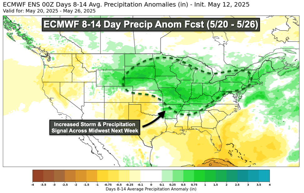
This week has brought a return to more regular precipitation chances, driven by a cut-off low currently spinning over the Ohio Valley. Early-week showers will be followed by a risk of severe weather on Thursday (5/15) and Friday (5/16). The southern half of the state faces tighter fieldwork windows due to recent moisture, while the northern half remains notably drier. While the latter half of this week will likely see some severe thunderstorm activity, the extent of storm coverage — and corresponding rainfall amounts — remains uncertain. While additional storm activity is likely next week, as evidenced by greater precipitation totals forecast by the ECMWF, I have yet to see consistent signals of a broader, wetter pattern developing through late May. Until that occurs, my concerns over drought particularly in northern Illinois, remain significant.
As we move toward June, these shifting patterns will play a critical role in shaping the outlook for both planting and yield potential. With drought concerns lingering and the atmosphere showing signs of reduced momentum, every storm and rainfall event will carry heightened significance for growers across the Midwest. It’s a reminder that while seasonal forecasts offer a glimpse into the months ahead, real-time observations and short-term trends often have the final say.
Matt Reardon
matt.reardon@nutrien.com
 and then