
August might be my least favorite month. Football and basketball haven’t quite started, the mid-summer doldrums linger, and that familiar, stale and humid air settles over Illinois. Thunderstorm chances thin out, and we wait for the calmer stretch that often precedes fall. Meanwhile, the tropics wake up. When the Atlantic stirs, our guard goes up.
That’s been the case this August. What began as a closer of storms off Africa slowly intensified into Hurricane Erin. For a time, the forecast track wobbled between a clean “out to sea” solution and a closer brush with the U.S. mainland. The result landed in between. Erin, still carrying some of its earlier strength, pulled away from the East Coast, but the near-miss was enough to bring deadly rip currents, high surf, coastal erosion, and tropical rains to parts of North Carolina under tropical storm watches. The Outer Banks even saw mandatory evacuation orders.
Looking forward, the Atlantic still has a few features worth watching through month’s end. That said, large-scale conditions look likely to tamp down development in early September. Later in the season, the focus could shift to “home-grown” systems in the Gulf of Mexico or the Caribbean rather than long-track African waves. Some seasonal guidance even highlights the Bay of Campeche as an area to watch as we move through the latter half of hurricane season.
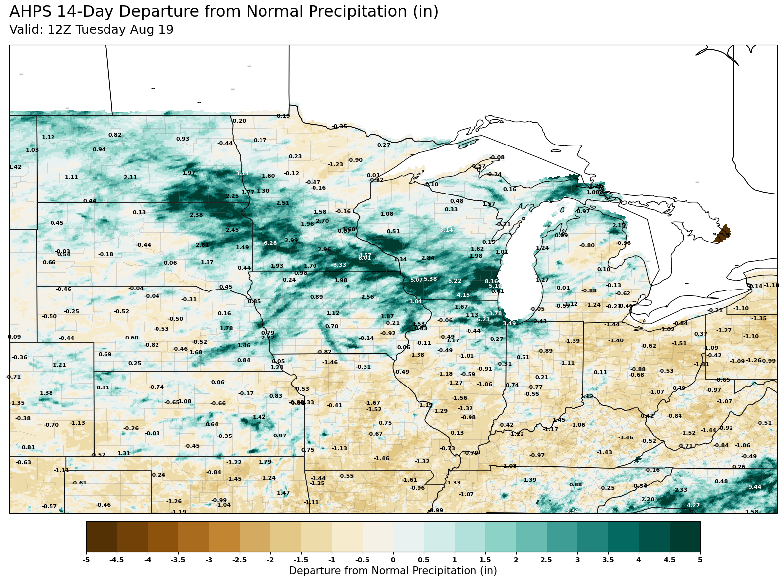
AHPS Observed Precip (8/5 – 8/19)
Closer to home, persistent thunderstorms have brought repeat flooding to northern counties in the state. Cloudburst storms flooded parts of Chicagoland and smaller communities like Paw Paw. Events on July 8, July 25, and August 16–18 produced multiple rounds of flash flooding and plenty of storm reports across the state. Severe wind gusts and hail dotted the Chicago metro before storms sagged southeast, with some winds laying down corn stands as far south as Homer.
By contrast, central and southern Illinois have been comparatively dry since late July. Springfield, for example, hasn’t recorded a quarter-inch-plus event since last month. That kind of short-term dryness matters in August; corn and soybeans are maturing, and moisture deficits translate quickly into yield impacts. The dryness was compounded by periodic heat in mid-month, with mid- to upper-90s and heat advisories returning for a few days.
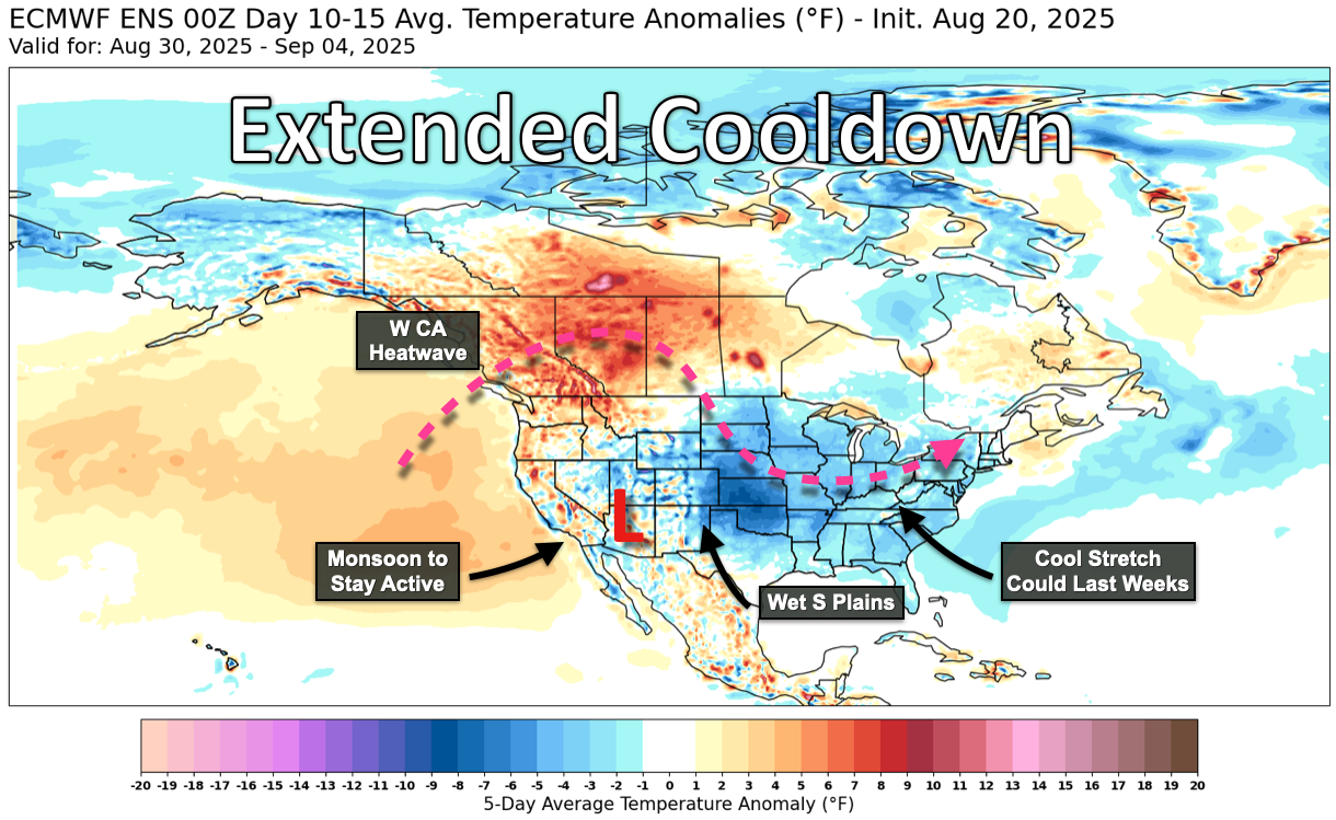
ECMWF ENS 5 Day Temp Anomaly Forecast (8/30 – 9/4)
The good news: the last two weeks of August—and possibly even early September—are poised to flip the script. A pronounced cooldown is on the way. Overnight lows will fall into the 50s for most counties and may dip into the 40s in the north early next week. It’s an early taste of fall across much of the Lower 48—one that, in my house, pairs nicely with a calendar already circled for August 29, when Illinois hosts Western Illinois in Champaign.
This cooldown looks sticky enough to lend a lasting crispness into September. Long-range guidance shifts late-August heat into the Northwest U.S. and western Canada, opening the door for a cooler Canadian air mass to spill into the central and eastern states. There is a catch: these Canadian highs are often dry. Cooler air holds less water, and precipitation chances tend to wane under that regime. For acreage in central, southern, and western counties that missed the mid-August storms, a cooler but drier pattern is not ideal.
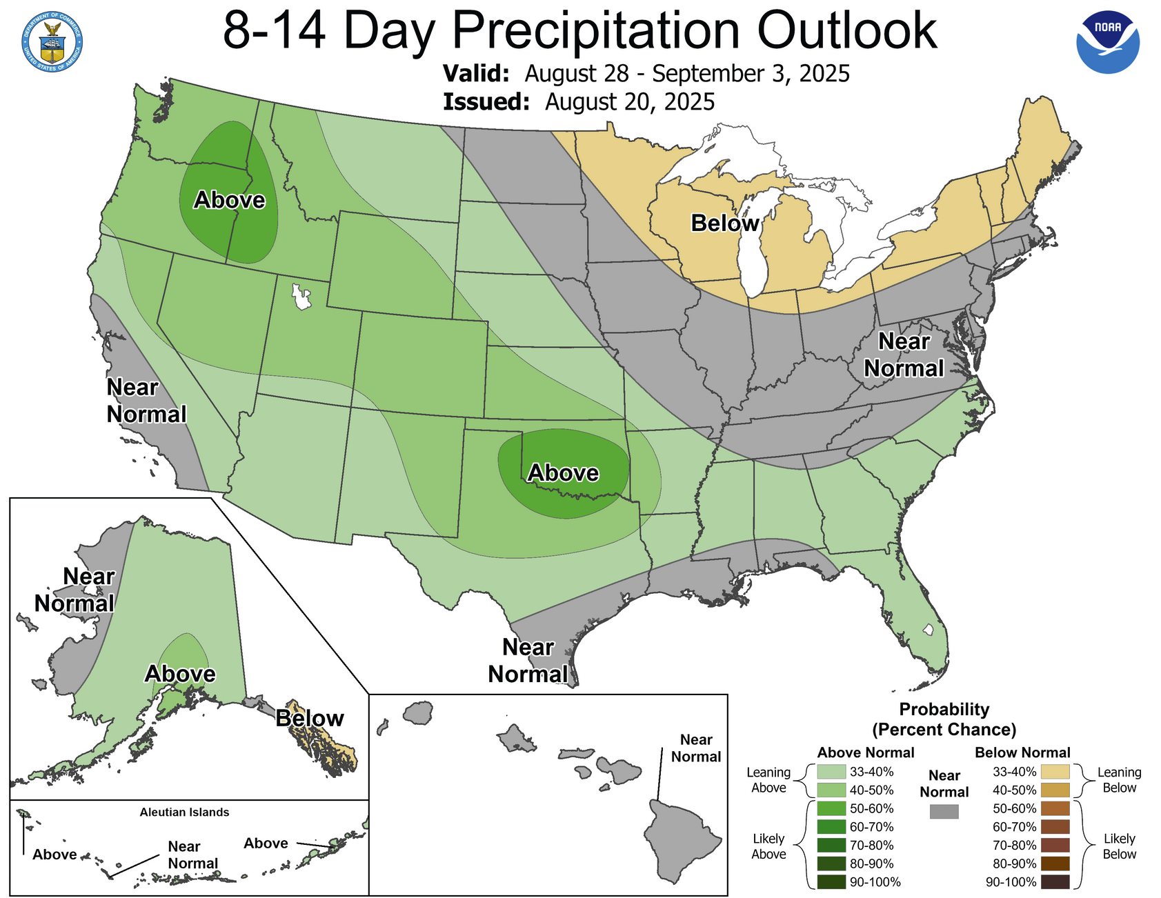
Climate Prediction Center’s 8-14 Day Precip Outlook (8/28 – 9/3)
What does autumn look like from here? Signals are mixed, which is what you would expect in August. One factor is the increasing likelihood of a La Niña episode by winter—NOAA recently issued a La Niña Watch. Historically, La Niña can lean drier across parts of the Midwest in fall before giving way to a more active winter pattern. Seasonal model suites such as the ECMWF and NMME are not unanimous: some keep the drier signal centered farther west into the Plains rather than directly over Illinois. When guidance is split, I lean on persistence—the atmosphere’s stubborn habit of extending recent trends. Lately, that has looked like a wet upper Midwest with comparatively drier counties south of I-74.
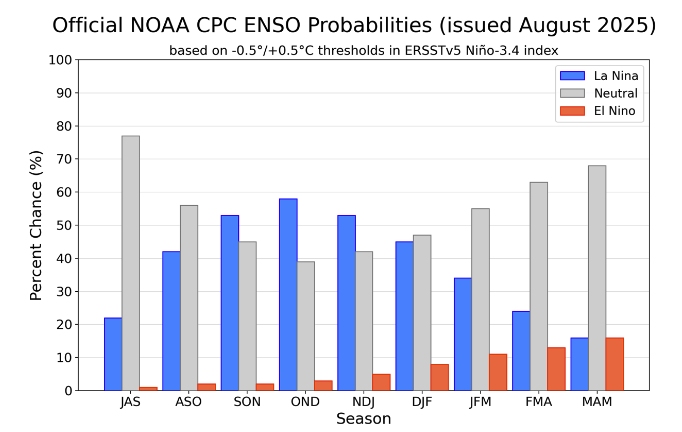
CPC ENSO Probabilities & Forecast
I’m often asked about early frost risk this time of year. It’s a fair question, but it hinges on one number, 32°F, and whether we briefly touch it on a particular late-September morning. That level of specificity is beyond reasonable forecast accuracy this far out. Two broader points are more helpful. First, first-frost dates in Illinois have trended later over time, indicative of a broader growing season length uptrend. Second, a shift toward La Niña typically correlates with warmer conditions in September and October for parts of the region. Early frost? Consider me skeptical on both counts, with the usual caveat that radiational cooling under a clear, calm high can still surprise a few low-lying fields.
Why this matters for growers and buyers
- Moisture timing: A cooler pattern reduces evapotranspiration stress, but if rain chances also dip, subsoil moisture won’t rebuild. Late-August to early-September showers—when they occur—will be disproportionately valuable for soy fill and for stabilizing late-planted corn.
- Wind and lodging: July’s severe wind gusts already flattened a few stands. As crops dry down, susceptibility to lodging changes; keep scouting high-risk fields, especially where July winds hit and stalk quality is questionable.
- Disease pressure: Cooler, drier air can briefly tamp down foliar disease spread, but humidity pockets around the canopy still matter. Field-level scouting will beat any regional map in the next three weeks.
- Marketing decisions: Mixed seasonal signals argue for flexibility. If your operation tends to pre-price on the expectation of a drier fall, keep an eye on persistence: if the north stays wet and the south stays drier into September, local basis and harvest pace will reflect that imbalance.
What to watch in the next 2–4 weeks
- Tropics shifting west: Fewer long-track threats doesn’t remove risk. Any late-season Gulf or Caribbean development can change rainfall distribution across the Mississippi Valley quickly.
- Front placement: Under a cool high, the difference between a soaking and a shut-out can be 50–100 miles. Watch where fronts stall; local totals will be driven by repeat thunderstorm clusters along those boundaries.
- Soil moisture gradients: The line between “adequate” and “running on fumes” has been sharp this year. County-level maps hide a lot of field-scale variability; plan harvest order with that in mind.
- First cool snap vs. frost: I expected crisp mornings, not widespread frost. A handful of favored low spots in northern counties could briefly flirt with the 30s under ideal radiational cooling, but a region-wide first frost looks unlikely in the near term.
In short, August is finally loosening its grip. We’ll trade heat for crisp mornings—and, unfortunately, probably trade some rain chances, too. For producers and buyers, the next few weeks are about threading the needle: grabbing whatever late-season moisture arrives, managing field-level risks from earlier wind and uneven rainfall, and staying nimble while bigger-picture signals (including La Niña) come into sharper focus. Fall is coming. The weather will change. The challenge, as always, is turning that change into decisions that pay.
Matt Reardon