Saturated Soils
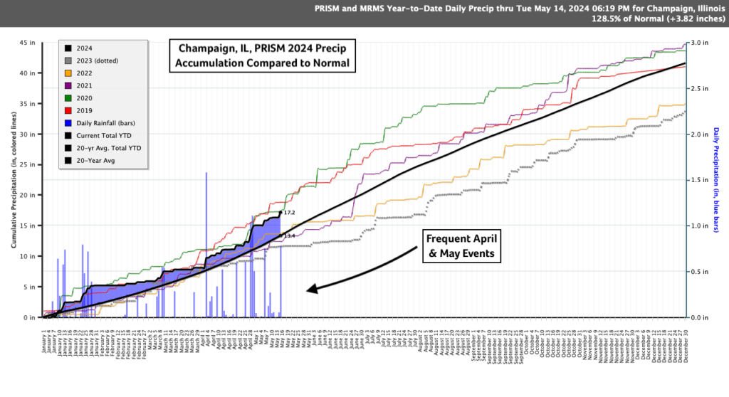
Frequent rainfall events have slowed planting across Illinois and the Central Corn Belt. The USDA’s latest crop progress report, released on May 13th, shows the state significantly lagging last year’s progress, with corn and soybeans below their five-year average for this date. A combination of frequent and occasionally heavy rainfall has increased soil moisture and reduced the number of suitable fieldwork days. The graph below shows this year’s rainfall accumulation for Champaign, IL, through May 13th. Precipitation has tracked above the 20-year normal accumulation (black line) there. Notice the frequent events, or stair-steps, through the end of April and the beginning of May.
Of course, the silver lining is that we have begun the growing season with few areas of drought concern and a surplus of soil moisture. However, having a crop to capitalize on that moisture would be welcome. Attention now turns to the near term forecast in search of an extended dry stretch.
Near Term Forecast
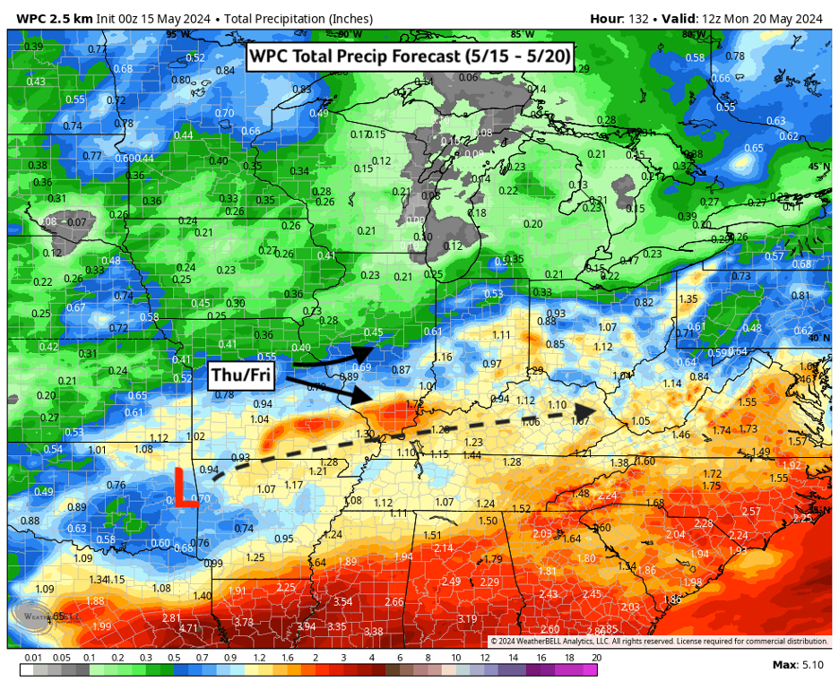
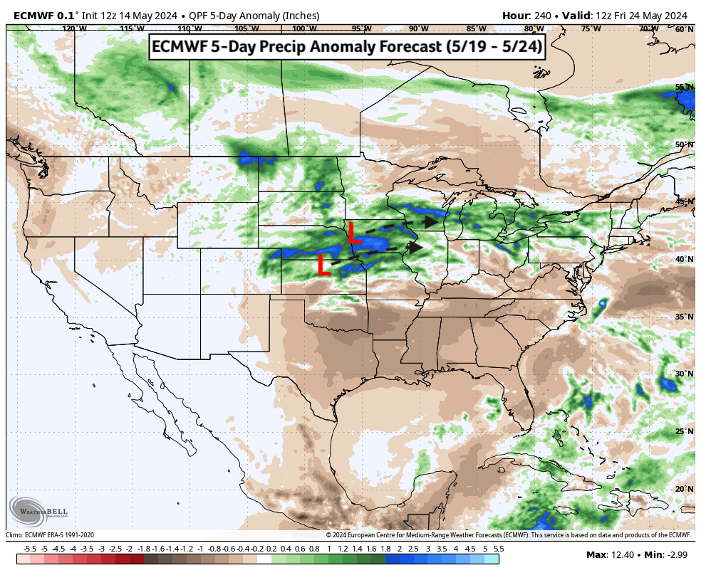
The end of this week will see daily chances of showers and storms on Thursday (5/16) and Friday (5/17) as a weak low-pressure system tracks east through the Ohio Valley. Rain chances and accumulations are expected to be greater in the southern half of the state, especially along I-70 and areas south. Lesser amounts are expected in northern counties at least until early next week. Current forecasts highlight a repeat storm track through Iowa and Northern Illinois next week. This could bring daily storm chances for northern counties, particularly north of I-80 or even I-88. Given that this activity is forecast for next week, there is some uncertainty regarding the location and timing. Regardless, renewed storm chances are likely early next week for the state.
The good news is that the late week storms this week are not expected to be particularly severe, with the Storm Prediction Center only highlighting Southern Illinois with a marginal risk for severe weather Thursday. After a fast start to the peak severe weather season in the Plains, which saw multiple deadly EF4 tornadoes, Illinois has had relatively fewer significant severe weather reports. That could change in as early as next week as storm chances return.
The seven-day forecast highlights a small window for northern counties to see drier conditions through the weekend, but this window is likely to close early next week. Conversely, Southern Illinois will likely have to wait until the weekend to see a break in the rainfall.
Long-range Forecast
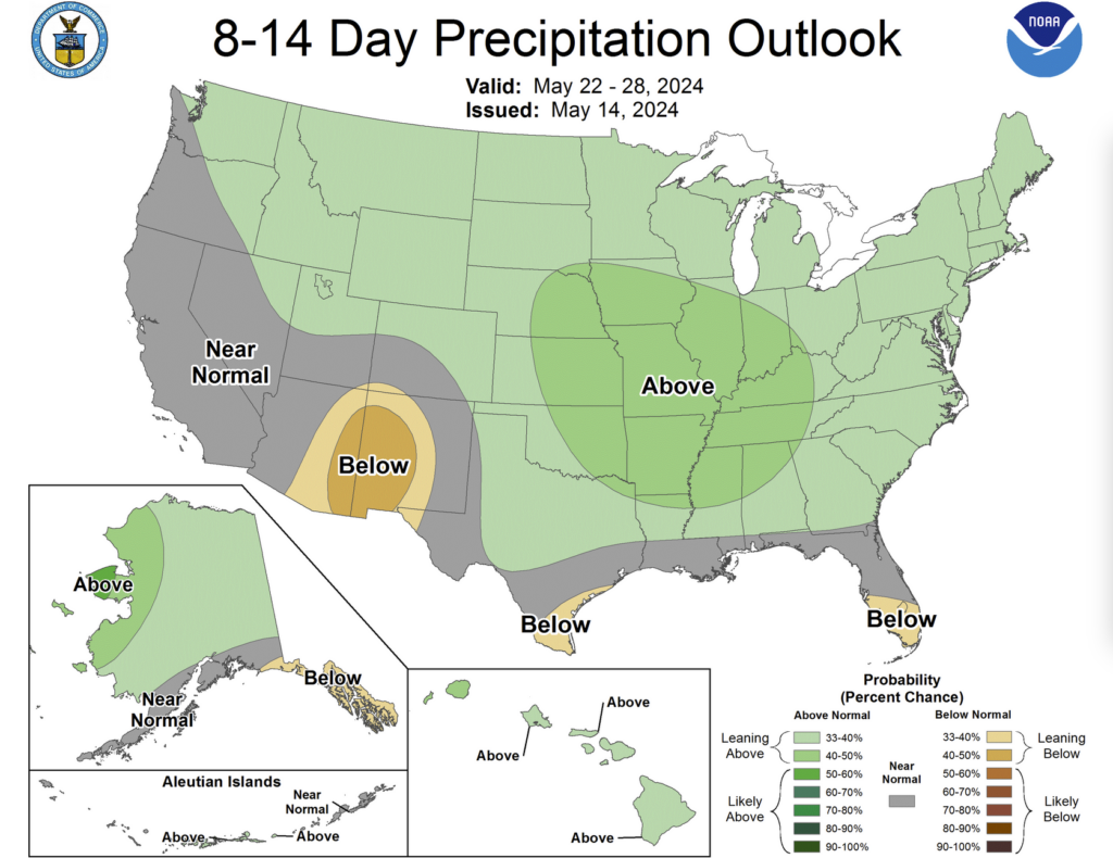
Long-range forecast models like the ECMWF and GFS indicate increased chances for Corn Belt rains through late May. Persistent troughing in the Western US, which has helped guide low-pressure systems across the Plains and Midwest this spring, is forecast to continue into the last week of May. As a result, precipitation forecasts for the third and fourth weeks of May remain wetter than average for much of the Midwest, including Illinois. There is always some uncertainty in long-range forecasts, but this pattern has been persistent and there is strong agreement between different forecast models. Unfortunately, this puts added pressure on growers to find planting windows during this mid-month timeframe.
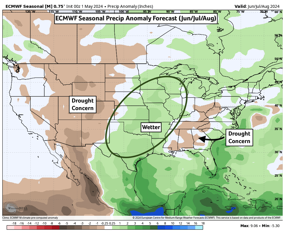
This time last year, we were facing a significant multi-week drought that caused crop prices to rally through June. This year is already looking noticeably different. Seasonal forecasts for the warmest summer months suggest better chances for near to above-normal precipitation, along with above-normal temperatures for the state. These forecasts align with previous analog years that saw a transition from El Niño at the start of the year, as we did, toward neutral or La Niña conditions later in the year, as is expected.
A warmer, stormy summer could bring its own challenges if severe thunderstorm wind or hail events persist into the mid or late summer months with mature crop stands. Then again, that late summer corn-fed heat, the sound of crickets, and an evening punctuated with an electric light show is a quintessential Illinois experience every July. Let’s just hope it doesn’t come by way of a damaging derecho.
This most recent El Niño episode is nearly behind us in May. The CPC didn’t officially declare its departure in their latest update (5/9), but that just makes it even more likely next month. La Niña could replace El Niño sometime this year, possibly as early as mid-summer. Rapidly cooling waters in the Eastern Tropical Pacific are increasingly apparent when looking at the latest sea surface temperature anomalies. The emergence of La Niña can increase drought chances in the Central US, and its arrival is often a concern for those of us in agriculture. La Niña, characterized by cooler ocean temperatures in the Central Tropical Pacific, can weaken jet stream flow across the United States and reduce regular rain chances and storm tracks. That said, La Niña won’t develop overnight, and the timing of when those cooler waters develop across the Central Pacific, along with ocean temperature patterns in the North Pacific, will play an important role in determining this summer’s precipitation pattern. For now, current forecasts suggest a slowly developing La Niña is unlikely to extend drought into the Central Corn Belt and Illinois this summer.
Lastly, this summer will feature another quintessential Illinois experience with the imminent hatching of periodical cicada broods. These cicadas are different from the more typical annual cicadas and have already begun to flood trees in Southern Illinois counties with countless bugs. Very loud choruses of their mating calls will soon spread north across Illinois and could create a memorable early summer experience unique to 2024.


 and then